
Loss and damage of can tho agriculture in vietnam due to climate change
Keywords:
Climate Change, Loss and Damage, Can Tho, Agromeshell, Geographic Information, System (GIS)Abstract
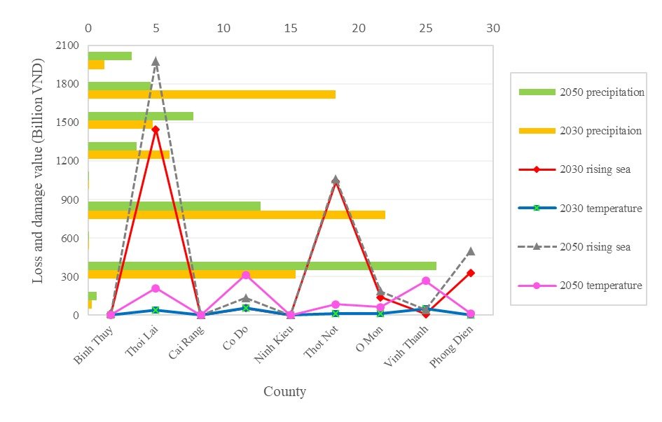
This research used Agromeshell model combines with spatial distribution and analysis in GIS to estimate loss and damage in Can Tho agriculture, which is represented by rice productivity and cultivating land. The result indicated that Thoi Lai county has the highest loss/damage risking, gains 1448.16 billion VND in 2030 year and 1975.62 billion VND in 2050 year. Binh Thuy has the lowest loss/damage risking with 15.39 billion VND in 2050 and Vinh Thanh has the least loss/damage value in 2030 year with 9.01 billion VND by rising sea level. Thoi Lai has the highest loss/damage risking in 2050 year with 25.81 billion VND; Vinh Thanh county has the highest loss/damage risking in 2030 year with 18.35 billion VND by precipitation. Co Do County has the highest loss/damage risking in 2030 and 2050 year with 57.82 billion VND and 314.32 billion VND by temperature. Ninh Kieu county has the least loss/damage value in 2030 and 2050 year by affecting of precipitation as well as temperature in climate change. Therefore, this article revealed estimation of loss and damage risking in applying amalgamation of agromeshell model and GIS.
Downloads
Published
How to Cite
Issue
Section
Copyright (c) 2023 Minh Thu Nguyen

This work is licensed under a Creative Commons Attribution-NonCommercial 4.0 International License.

